
Arizona Trail – 2012
Why the Arizona Trail (AZT)?
My original intention was to hike the Pacific Crest Trail in 2012 considering I had previously done so much research and planning over the years. But something changed my mind, at least for this year. Firstly, it may be the recent move to Arizona after being away for over 30 years. Secondly, it could be that I have also appreciated the diversity and beauty of this state. Thirdly, it may be that some of the last connecting sections of trail have recently been completed. As a matter of fact, the Arizona Trail passes within six miles of our home at the base of the Catalinas. And lastly it could be that my wife has offered to be my No. 1 Trail Angel! Therefore, it stands to reason the Arizona Trail (AZT) was an obvious choice for my first thru-hike!
AZT – What & Where?
The Arizona Trail (AZT) stretches about 800 diverse miles from Mexico to Utah and connects and unquestionably showcases deserts, mountain ranges, canyons and forests. The AZT was designated as a National Scenic Trail in 2009 and subsequently completed in late 2011.
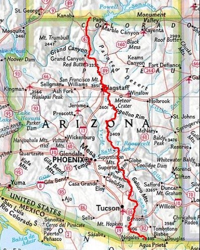
To begin with, The AZT starts at the Coronado National Memorial and border with Mexico. The trail then passes through some of SE Arizona’s Sky Islands, a very fitting term used to describe isolated mountain ranges that rise abruptly from desert valleys, creating distinct, high-elevation ecosystems with unique animals and plants. And believe me, without a doubt, the elevation changes! The trail continues north of Tucson through the Superstition Mountains, Four Peaks and Mazatzal Mountains before ascending the Mogollon Rim north of Payson. Thereafter comes the higher elevations of Northern Arizona, the San Francisco Peaks and across the Coconino Plateau. And finally, in and out of the Grand Canyon to the Arizona-Utah border in the Kaibab Plateau region.
The AZT passes through four National Forests, eight Wilderness Areas and two National Parks. The total elevation gain along the AZT is approximately 113,000 feet.
The Arizona Trail Association website, http://aztrail.org, has a wealth of information on the trail and is very helpful.
AZT Daily Posts
My daily blogs and other posts related to the AZT are found below:
- AZT: Preparation
- AZT: Updated Plans
- AZT: Water
- AZT Day 1: Border, Huachuca Mtns
- AZT Day 2: Between Sky Islands
- AZT Day 3: Canelo Hills
- AZT Day 4: Patagonia
- AZT Day 5: Santa Rita Mountains
- AZT Day 6: Santa Rita Foothills
- AZT Day 7: Between Sky Islands (Again)
- AZT Day 8: Nearing Tucson
- AZT Day 9: Rincon Valley
- AZT Day 10: Top of the Rincons
- AZT Day 11: Down, Down to Redington Road
- AZT Day 12: Across to the Catalinas
- AZT Day 13: Up, Up and Away!
- AZT Day 14: Oracle Ridge
- AZT: Break Time
- AZT Day 15: North from Oracle State Park
- AZT Day 16: Antelope Peak, Bees and Lots of Cactus
- AZT Day 17: Powerline, Washes & Hills
- AZT Day 18: Gila River & Walnut Canyon
- AZT Day 19: White Canyon Wilderness
- AZT Day 20: Picketpost Mountain & Superior
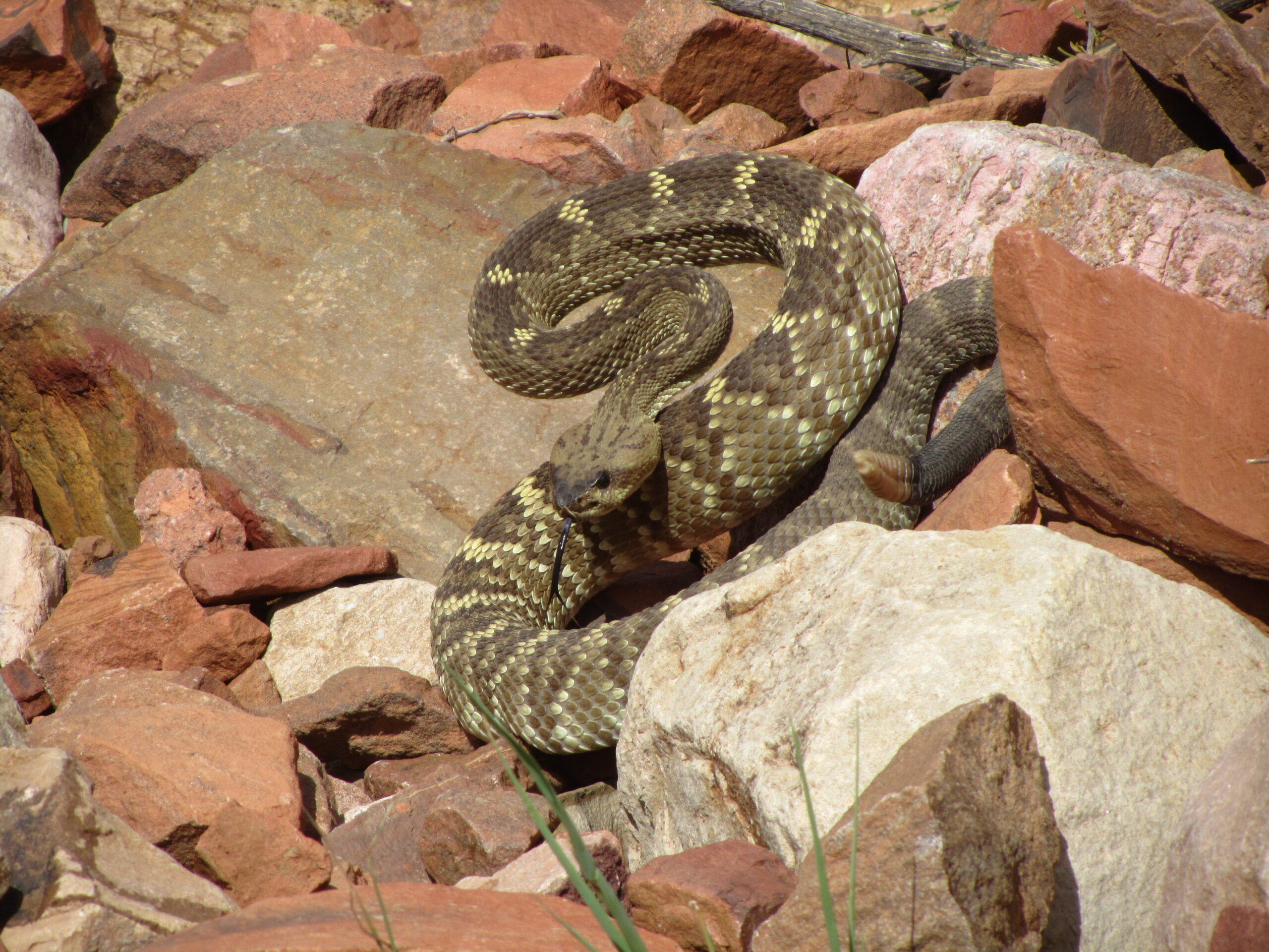
- AZT Day 21: Superstitions and Rattlesnakes
- AZT Day 22: Rugged Superstitions
- AZT Day 23: Roosevelt Lake
- AZT Day 24: Four Peaks
- AZT Day 25: Four Peaks to Sycamore Creek
- AZT Day 26: Saddle Mountain
- AZT Day 27: Mazatzal Divide Attempt
- AZT Day 28: Rest of Mazatzal Divide
- AZT Day 29: Red Hills to Whiterock Mesa
- AZT Day 30: Hardscrabble Mesa into Pine
- AZT Day 31: Zero Day in Pine
- AZT Day 32: Mogollon Rim
- AZT Day 33: Blue Ridge into Happy Jack
- AZT Day 34: Mogollon Plateau, Jack’s Canyon
- AZT Day 35: Mormon Lake to Anderson Mesa
- AZT Day 36: Anderson Mesa to Walnut Canyon
- AZT Day 37: Stroll into Flagstaff
- AZT: Snowing in Flagstaff
- AZT Day 38: San Francisco Peaks
- AZT Day 39: Babbitt Ranch
- AZT Day 40: Babbitt Ranch to Coconino Rim
- AZT Day 41: Into Tusayan
- AZT Day 42: Grand Canyon – South Rim
- AZT Day 43: Grand Canyon Tourist
- AZT Day 44: South Rim to Cottonwood CG
- AZT Day 45: North Rim & Beyond
- AZT Day 46: Kaibab Plateau
- AZT Day 47: Jacobs Lake & Kaibab Plateau North
- AZT Day 48: Buckskin Mountain & Finish
- AZT: Final Thoughts