

Grand Enchantment Trail – 2018
Why the Grand Enchantment Trail (GET)?
So many people have asked me if and when I am going to hike the Appalachian Trail (AT) and complete the Triple Crown. Although the AT may appeal to me someday, there are still too many trails in the West that are high on my list. I am also drawn to the less traveled, more remote expanses, like what the Grand Enchantment Trail offers.
I do love spring hiking in the desert – I guess that’s why I have hiked all my long routes from south to north thus far. All my senses are especially heightened by the smell of flowers and desert plants, the vivid colors of blooming flowers, cactus, sunrises and sunsets, the sound of birds and trickling water that only flows in the spring, the brilliant night skies and the sometimes frigid mornings and cool evenings.
So it’s no surprise that the Grand Enchantment Trail (GET) and the Hayduke Trail ((HDT) have been high on my list since finishing the Arizona Trail several years ago. In this case, the GET won out this year and I have absolutely no regrets!
The GET also connects some of my old adventures and memories of the Southwest. Some of my first backpacking trips with my dad and friends in the late 60’s/early 70’s were in the Superstitions. In fact, the only time I have ever been shot at while hiking was near Superstition’s LaBarge Canyon – I always imagined it was an old, crusty. gold-fevered prospector. While in college, I worked summers at the old Magma underground copper mine near Superior AZ. While living there, I witnessed one of the largest, most entertaining bar fights I have ever seen at a lounge next to Los Hermanos restaurant off of Hwy 60.
GET – What and Where?
The Grand Enchantment Trail stretches from the Superstition Mountains near Phoenix AZ east to Sandia Peak on the outskirts of Albuquerque NM. What’s more, the 770-mile route is the creation and brainchild of Brett Tucker who conceived this route in 2003. The GET links hiking trails, animal paths, drainages, dirt roads, some cross-country bushwhacking and a bit of pavement. It also connects with several miles of the Arizona Trail and about 45 miles of the Continental Divide Trail in Mew Mexico’s Black Range above the Gila River.
A few useful and informative links include Brett’s http://grandenchantmenttrail.org and http://simblissity.net.
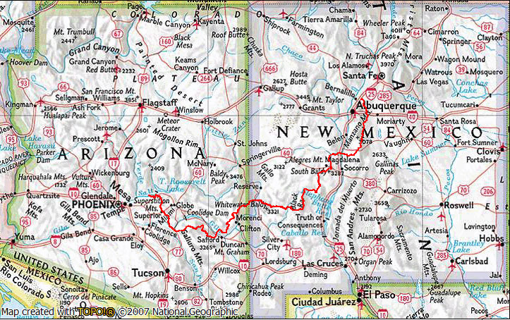
Additionally, the GET passes through six National Forests, four Wilderness Areas and has an estimated total elevation gain of 82,500 feet.
Not to mention one of my favorite stops on the AZT that I saw again on the GET was the Walnut and White Canyon areas near the Gila River south of Superior. Over the years, I have camped and hiked in the Pinalenos near Safford and the White Mountains near GET’s Blue River in eastern Arizona, and finally, many fond memories of New Mexico’s numerous Gila River crossings, cliff dwelling visit and stop at Doc Campbell’s on the CDT and GET.
GET Daily Posts
All that and more in my daily blogs below that connect all these dots and adds new adventures and memories of beautiful Arizona and New Mexico hiking:
- GET: Plans & Recent Injury
- GET: Gear, Food & Caches
- GET Day 1: Superstition Wilderness
- GET Day 2: Another Superstition Day
- GET Day 3: Rogers Canyon to Whitford Canyon
- GET Day 4: Into Superior
- GET Day 5: A Superior Zero Day
- GET Day 6: Picketpost TH to Walnut Canyon
- GET Day 7: To the Gila River and Tortilla Mountains
- GET Day 8: Tortilla Mountains to Freeman Road TH
- GET Day 9: Leave AZT to Hwy 77 & Mammoth
- GET Day 10: Brandenburg Ranger Station
- GET Day 11: To the Edge of Aravaipa Canyon
- GET Day 12: Aravaipa Canyon Wilderness
- GET Day 13: Klondyke & Santa Teresa Range
- GET Day 14: Pinaleno Mountains
- GET Day 15: Clark Peak and the Swift Trail
- GET Day 16: Top of Pinalenos and Long Way Down
- GET Day 17: Into Safford on a Hot Day
- GET Day 18: Zero Day in Safford
- GET Day 19: Safford-Morenci Trail
- GET Day 20: Midnight Canyon & Eagle Creek
- GET Day 21: Eagle Creek to Hwy 191, Morenci
- GET Day 22: Zero Day in Morenci
- GET Day 23: Another Zero Day in Morenci
- GET Day 24: Granville CG to Juan Miller Road
- GET Day 25: Blue River Country
- GET Day 26: Maple Peak & Down to Alma NM
- GET Day 27: Mineral Creek and into the Mogollons
- GET Day 28: Gila Wilderness & Mogollon Baldy
- GET Day 29: West Fork Gila River
- GET Day 30: Into Gila Hot Springs
- GET Day 31: Zero Day in Gila Hot Springs
- GET Day 32: The Black Range
- GET Day 33: Aldo Leopold Wilderness
- GET Day 34: Another Day in the Black Range
- GET Day 35: Gate and Fence Day
- GET Day 36: Short Walk to NM Hwy 52
- GET Day 37: Zero Day in Chloride NM
- GET Day 38: San Mateo Foothills
- GET Day 39: San Mateos, Apache Kid Wilderness
- GET Day 40: Still in the San Mateos
- GET Day 41: Potato & Big Rosa Canyons
- GET Day 42: Into Magdalena
- GET Day 43: Zero Day in Magdalena
- GET Day 44: La Jencia Wash & San Lorenzo Arroyo
- GET Day 45: Into Socorro NM
- GET Day 46: Sevilleta National Wildlife Refuge
- GET Day 47: On to US 60 & into Mountainair
- GET Day 48: Zero Day in Mountainair
- GET Day 49: Manzano Mountain Wilderness
- GET Day 50: Manzano Mountains
- GET Day 51: Tanique & The Manzanita Mountains
- GET Day 52: Sandia Mountain & Finish!
- GET: Closing Comments